Wednesday, August 5, 2009

Rough Riders at Mt. Shasta

An annual AdventureCORPS tradition at Mt. Shasta - the magical, mystical mountain which stands serenely near the top of California - continued when 15 riders converged for CORPScamp Shasta on July 29 through August 2, 2009. This glacier-laden volcanic peak provided the backdrop for superb cycling in a gorgeous, alpine region with dramatic lakes, rivers, forests, and memorable climbs. The camp concluded with participation in the Shasta Summit Century, an epic and challenging event!

Each day began with the Ron Jones Dynamic Warm Up and featured a wonderful ride in a spectactular setting with little to no traffic. Each afternoon featured a yoga class for cyclists, including those with no yoga background (most of the group), and was designed to help each camper unwind, accelerate recovery for the next day's adventure, minimize the chance of injury, and rejuvenate and restore energy balance. Two wonderful meals catered by Chris & Dena's Deli were hosted outdoors at the beautiful Strawberry Valley Inn and provided more opportunities to socialize, enjoy great food, and win raffle prizes.

One CORPScamp rider was John Marino, the godfather of ultracycling who essentially created the sport of ultracycling as we know it, and also created the Great American Bike Race, Race Across America, and Furnace Creek 508. Now 60, John still rides at the same weight as he did 30 years ago. The first evening of the camp we watched "Psychling," the documentary film about his 1980 Guinness Book transcontinental cycling record, then on Friday we watched the ABC coverage of the 1982 Great American Bike Race, both evenings providing entertaining insights into the past, present, and future of long-distance cycling and the man who brought the sport to life.

Another special guest who also rode the entire camp was Jeannie Ennis, a competitor in the very first Badwater Ultramarathon in 1987. She was inducted into the Badwater Hall of Fame in 2005. She has been a cyclist for many years, riding cross-country from WA to ME as well as from Canada to Mexico on the Continental Divide. Now 62, this living legend of ultra sport has not slowed down and is still pursuing health and fitness and new aspirations and goals. She, and Marino, were a delight to ride with and learn from.

Another legend of ultra sports who was on hand for the duration of the event was local resident Scott Weber, who drove the support vehicle and tended to the riders, dispensing Hammer Nutrition products, water, fruit, and copious, priceless wisdom each day. Scott is a 13-time Badwater Ultramarathon finisher, has been a highly sought out running coach since 1988, and - in his previous life as a cyclist - was a cycling cast member of the cycling film "American Flyers" in 1986!

It was truly a pleasure to ride on and around Mt. Shasta for five days, to get to know a really wonderful group of adventure-athletes, and to socialize in a very special place. To all the riders, and our super supporter Scott Weber, we say "thank you" for supporting this event!

For two slideshows of all the action and adventure, click here.

We hope to see even more Rough Riders there next year!

Above: Jeff Martin and Jo Carmichael ascend Mumbo Summit

Above: Chris Kostman descends Mumbo Summit in his "no-handed tuck" pose he invented during the 1987 Race Across America. (Photo by Jo Carmichael)

Sunday, July 5, 2009

Boulder Creek Semi-Epic Ride on July 5, 2009: Ride Report, Images, and Video

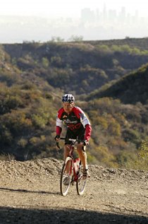
After first riding different parts of this route over the past year (see the videos here on YT) we invited others to join us for a Rough Riders Semi-Epic Ride on July 5, 2009. Eleven riders enjoyed a fantastic day of cycling in the first real hot weather of 2009: It hit about 100 at some points. The route featured "the greatest hits" of the Mt. Laguna back country: Viejas Grade, Boulder Creek, Lake Cuyamaca, Descanso, and Wildwood Glen Ln (AKA "Mad Max Road") with a start/finish in Alpine, CA. Total distance: 58 miles with over 8,000' of elevation gain. This route can best be ridden by an accomplished rough rider on a bike with 32mm or wider tyres. This is really a phenomenal ride and we highly recommend it!

Above: Viejas Grade
Above: Descanso store
Above: Boulder Creek
Above: Peter Bridge at the bottom of Boulder Creek
Above: Boulder Creek at the very bottom. Not much water in July!
Above: Catching some shade on the ascent out of Boulder Creek
Above: Working our way up and out of Boulder Creek
Above: Rookie Rough Rider Eric Larson with his Moots YBB CX
Above: After a refresh/refuel at Lake Cuyamaca

Here's a link to the video slideshow.
Turn up your speakers: enjoy the music & pix!

Route Sheet:
The 58 mile loop starts and finishes at the relatively new Starbux located at 2963 Alpine Blvd in Alpine, CA 91901 (along the I-8 corridor in eastern San Diego County). (Start location and mapping here.)
0.0 Start at Starbux in Alpine and head east on Alpine Blvd. (El. 2080')
1.1 Cross over I-8 at West Willows Rd.
1.3 Continue east on the opposite (north) side of the freeway.
2.1 Veer left shortly thereafter on Viejas Grade Rd. into the Indian Reservation.
4.7 Road turns to gravel - head uphill into Rough Rider heaven!
8.6 Summit Viejas Grade (still gravel).
9.0 Pavement resumes: Continue straight and downhill to Descanso.
11.2 Left on Oak Grove Drive (at Perkins Store in Descanso: GET WATER!)
12.8 Right on Boulder Creek (but first check out the llamas on the left at the turn).
16.6 Pass Sherilton Valley Road (Need to investigate this road. Looks interesting.)
16.9 Pass Dubois Truck Trail on left (Need to also research this dirt road). (El. 2780')
17.9 Pavement ends! (El. 3340')
23.6 Bottom of the canyon. Careful for water running across the road. (El. 2500'; 2:30 elapsed time)
24.0 Pass Ranchita Margarita: watch for ostriches.
24.5 This is the very bottom of Boulder Creek Canyon, during 1/3 mile of pavement.
25.7 Pass two truck trails on the left at a hairpin. (Need to research them, too!) (El. 2780')
29.5 Tiny church and a cemetery on the right, within the Inaja Reservation.
29.8 Mile Marker 17. (El. 3630'; 3:40 elapsed time)
30.8 Pavement resumes: Right (uphill) on Engineers Road at Pine Hills Fire Station (where you can get water if you need it).
34.7 Summit.
36.0 Right on SR 79
(Stop Sign, T-Int.): Go around Lake Cuyamaca.
36.6 Lake Cuyamaca Store on left; Food and drinks for sale. Bathroom down and around in back. (El. 4410'; 4:50 elapsed time)
39.0 Pass the Paso Picacho State Park on right; begin descent.
44.3 Pass East Mesa Fire Road on left (Must research this dirt road!) (El. 3770')
45.0 Pass Oakzanita Springs / 1000 Trails on left. Bathroom and store.
47.7 Pass Viejas Blvd on right (or you take it and get to the same place after passing the Perkins Store in Descanso); fruit stand.
47.9 Right to continue on SR 79 (Stop Sign, T-Int.). (El. 3390')
49.3 Pass Riverside Drive (our outbound route earlier). (El. 3210')
49.8 About a mile before hitting the I-8, turn right on Wildwood Glen Ln (AKA "Mad Max Road").
50.8 About a mile later, there is a gate across the road and then the pavement starts to disappear: keep going to the end!
52.1 Hike down onto I-8 and continue west on I-8 (this is a bike-legal shoulder).
53.5 Take first offramp, then left over the freeway, then right on Alpine Blvd, continuing west back to Alpine.
56.8 Cross West Willows Rd. (the way we headed out this morning); continue straight west.
58.0 Finish at Alpine Starbux.
(El. 2080'; 6:20 elapsed time)

Riders and Bikes:
Brad Zlotnick on his 1989 Miyata Elevation 5000 mountain bike (fully rigid)
Peter Bridge on his Redline CX bike
Dustin Sharp on his ti Black Sheep with Rohloff hub
Chris Kostman on his 1984 Holdsworth road bike with Ritchey 32mm cross tyres
Elizabeth on his 1974 Williams road bike converted to 650B wheels
John Byrne on his GT I-Drive with 6" of travel, front and rear mountain bike (dual suspension)
Bob Hartman on his Fuso by Dave Moulton
John Corkill on his Aegis carbon CX bike
Lawrence Cayton on his Lemond CX bike
Mark Tolivar on his 1972 Albert Eisentraut
Eric Larson on his ti Moots YBB XC bike

Thanks for your enthusiasm, everyone, and thanks especially to all the Rough Riders who rode today! We look forward to seeing you "out there" soon! (Stay tuned for the announcement of another Semi-Epic Rough Ride in the near future!)

Friday, July 3, 2009

New Logos, New Adventures

We are very excited to share the Rough Riders Rally logo with you here! This is an important step for us as we don't like to really move forward, publicly and officially, with a new event or endeavour until we have the logo ready. Well, the logo is done and the official RR Rally page is online here, so we hope you will mark your calendar for July 23-25, 2010 and plan to participate!


We've also revised the original Rough Riders logo: it has an updated Spanish Bayonet, the distinctive yucca plant which is featured on the logo and which we encounter so frequently here in Southern California on our cycling adventures. The original RR logo's Spanish Bayonet never quite "worked" for us; the new one is much more accurate. It will take a little while to get this new logo online everywhere we use it. If you're got the RR logo on your site or blog, thank you; please contact us to get the updated version to use (or just grab it from here, with or without the URL at the bottom)!

Finally, also here is a first look at the new Mount Laguna Bicycle Classic logo, which you will note incorporates the Spanish Bayonet, since they are to be found all over the Mount Laguna region and the route for this event. Although this event takes place entirely on paved roads, it is EPIC and it will be held in one of our favorite rough riding areas! Please also mark your calendars for April 17, 2010 for this exciting new event in southern San Diego County! More info about the MLBC.
All of these works of art were created by Bill Oetinger, a life-long endurance cyclist, charter member of the Rough Riders, and one of the main driving forces behind the legendary Terrible Two Double Century in Sonoma County. Thanks, Bill! Here is Bill's website; he's also an excellent bike tour organizer and purveyor of bike touring routes.

Tuesday, June 30, 2009

Monthly (more or less) Semi-Epic Rides: YOU Are Invited!

Greetings, Fellow Rough Riders!


We tackle Semi-Epic Rides semi-regularly and sometimes we announce them in advance and invite YOU along This will be the main page with an archive of the "group" rides we've done, plus a preview of what's coming up in the future. Please join us!

Upcoming Semi-Epic Rides:

February 5, 2011: Mount Laguna Back Country from Alpine, CA. (Same route as July 5, 2009). Join us!

Semi-Epic Ride Reports Archive:

May 1, 2010: Rough Riding Descanso - Boulder Creek - Lake Cuyamaca
On May 1 I joined a group organized by fellow Rough Rider Dustin Sharp for a 42-mile adventure in eastern San Diego County (near Mount Laguna, of course) with 5600 feet of elevation gain. Officially, it was a ride of the "Southern California Rivendell Appreciation Society." We spent six hours out there, four of them actually riding (with a route this unusual and in the back-country, you have to regroup often so that some riders don't end up as vulture dinner.) The route was a version of the ride we did out there on July 5, 2009, except this version had even more dirt: about 80% of the May 1 ride was off-pavement, some of it on true "mountain bike trails" with rock gardens, mud, single-track, portages, and more.

November 21, 2009:
Rough Riding the Santa Monica Mountains ALL THE WAY
On November 21, 2009 ten Rough Riders embarked upon a semi-epic (borderline EPIC) excursion in the Santa Monica Mountains. The ride leader was Chris Kostman. Six riders completed the full distance. It took eight hours to complete this route with a total distance of app. 45.7mi with 6110’ total elevation gain.

July 5, 2009:
Rough Riding the Mount Laguna Back Country
Eleven riders enjoyed a fantastic day of cycling
in the first real hot weather of 2009: It hit about 100 at some points. The route featured "the greatest hits" of the Mt. Laguna back country: Viejas Grade, Boulder Creek, Lake Cuyamaca, Descanso, and Wildwood Glen Ln (AKA "Mad Max Road") with a start/finish in Alpine, CA. Total distance: 58 miles with about 5000' of elevation gain.

June 14, 2009
: Rough Riding Mt. Palomar via Nate Harrison Grade
After first riding this route on November 6, 2009, we invited others to join us for a Rough Riders Semi-Epic Ride up Palomar Mountain via the unpaved Nate Harrison Grade on June 14, 2009. Twelve riders showed up for a fantastic day of cycling in uncertain weather.

May 17: 2009
: Rough Riding the Santa Monica Mountains
Five illustrious Rough Riders turned out for a 40-mile excursion in the Santa Monica Mountains on May 17, 2009, including Matt "Desert Locust" Ruscigno on a Bianchi 'cross bike, Ken Kistinger on a suspension-less Cannondale Killer V, Gary on a Bianchi single-speed 'cross bike, Chris Kostman on a 1984 Holdsworth road bike with 32mm 'cross tyres, and Jennifer Klausner on a suspended mountain bike. The route was 40 miles with 4850' of elevation gain, though 4500' of the elevation gain was in the first 25 miles.

Sunday, June 21, 2009

Semi-Epic Planned for Sunday, July 5: YOU Are Invited! Route Sheet Now Posted!

Mark your calendars and join us for a most excellent Rough Riding adventure! This semi-epic ride is planned for Sunday, July 5. The 58.4 mile loop we will ride starts and finishes at the relatively new Starbux located at 2963 Alpine Blve in Alpine, CA 91901 (along the I-8 corridor in eastern San Diego County). (Start location and mapping here.) We will meet there at 730am and roll out no later than 800am.

The route will include the dirt sections (and some paved sections) from two different rides we've done out in this amazing area before. Basically we'll ride a sort of "Greatest Hits" route which includes the dirt sections at the start and finish of this route (click these links for the full reports, but also check out the videos embedded below):

http://www.xo-1.org/2008/12/rough-riding-eastern-san-diego-county.html

along with the entire dirt Boulder Creek section featured in this route:

http://www.xo-1.org/2009/01/rough-riding-south-eastern-san-diego.html

We're hoping you will mark your calendar and join us for an AWESOME ride!

Note: This ride is unhosted, unsupported, and everyone who shows up is on their own. Neither we, nor anybody else, is responsible for anyone who rides. If you ride, YOU are responsible for YOU and YOUR bike. This is not an "event" - it is just a ride on dirt and paved roads for like-minded people.

Recommended Bikes / Tyres: In our opinion and experience, this route all rideable on a road bike with 28mm or wider tyres, although we have used 32mm and 35mm tyres. The wider your tyres, the more comfortable and safer your ride should be. Certainly a full-blown mountain bike will work, too. "Any Bike, Anywhere!"


Route Sheet Is Below (If you plan to ride this route, we suggest you print this section and bring it along. We will not be "guiding" this ride, as we are not in charge, nor "hosting" this ride. This route sheet should be about 98% accurate, but we make no guarantees. We suggest you consult a map and your own sense of direction. We accept no responsibility for safety, utility, nor legality of this route!) Dirt sections are noted in bold.

0.0 Start at Starbux in Alpine and head east on Alpine Blvd. (El. 2080')
1.1 Cross over I-8 at West Willows Rd.
1.3 Continue east on the opposite (north) side of the freeway.
2.1 Veer left shortly thereafter on Viejas Grade Rd. into the Indian Reservation.
4.7 Road turns to gravel - head uphill into Rough Rider heaven!
8.6 Summit Viejas Grade (still gravel).
9.0 Pavement resumes: Continue straight and downhill to Descanso.
11.2 Left on Oak Grove Drive (at Perkins Store in Descanso: GET WATER!)
12.8 Right on Boulder Creek (but first check out the llamas on the left at the turn).
16.6 Pass Sherilton Valley Road (Need to investigate this road. Looks interesting.)
16.9 Pass Dubois Truck Trail on left (Need to also research this dirt road). (El. 2780')
17.9 Pavement ends! (El. 3340')
23.6 Bottom of the canyon. Careful for water running across the road. (El. 2500'; 2:30 elapsed time)
24.0 Pass Ranchita Margarita: watch for ostriches.
24.5 This is the very bottom of Boulder Creek Canyon, during 1/3 mile of pavement.
25.7 Pass two truck trails on the left at a hairpin. (Need to research them, too!) (El. 2780')
29.5 Tiny church and a cemetery on the right, within the Inaja Reservation.
29.8 Mile Marker 17. (El. 3630'; 3:40 elapsed time)
30.8 Pavement resumes: Right (uphill) on Engineers Road at Pine Hills Fire Station (where you can get water if you need it).
34.7 Summit.
36.0 Right on SR 79
(Stop Sign, T-Int.): Go around Lake Cuyamaca.
36.6 Lake Cuyamaca Store on left; Food and drinks for sale. Bathroom down and around in back. (El. 4410'; 4:50 elapsed time)
39.0 Pass the Paso Picacho State Park on right; begin descent.
44.3 Pass East Mesa Fire Road on left (Must research this dirt road!) (El. 3770')
45.0 Pass Oakzanita Springs / 1000 Trails on left. Bathroom and store.
47.7 Pass Viejas Blvd on right (or you take it and get to the same place after passing the Perkins Store in Descanso); fruit stand.
47.9 Right to continue on SR 79 (Stop Sign, T-Int.). (El. 3390')
49.3 Pass Riverside Drive (our outbound route earlier). (El. 3210')
49.8 About a mile before hitting the I-8, turn right on Wildwood Glen Ln (AKA "Mad Max Road").
50.8 About a mile later, there is a gate across the road and then the pavement starts to disappear: keep going to the end!
52.1 Hike down onto I-8 and continue west on I-8 (this is a bike-legal shoulder).
53.5 Take first offramp, then left over the freeway, then right on Alpine Blvd, continuing west back to Alpine.
56.8 Cross West Willows Rd. (the way we headed out this morning); continue straight west.
58.0 Finish at Alpine Starbux.
(El. 2080'; 6:20 elapsed time)

Video of 2008 Rough Riding (cycling) Viejas Grade and Eastern San Diego County:
(Note: YouTube disabled the soundtrack. If you want to hear the music, and see the video much bigger and clearer, watch it here instead.)


Video of 2008 Rough Riding (cycling) Descanso - Boulder Creek - Lake Cuayamaca:
(Note: YouTube did not disable the soundtrack on this video, but if you want to see much bigger,and clearer, watch it here instead.)